The Colorado River
In 1869, Major John Wesley Powell, a one-armed Union veteran of the Civil War, led the first recorded expedition down the Colorado River, including the first documented passage through the Grand Canyon. Today, just seeing this river is a bucket-list item for many.
The Moab Information Center, in downtown Moab, has a special free exhibit celebrating the 150-year anniversary of Powell’s historic journey.
Pulse of the Desert
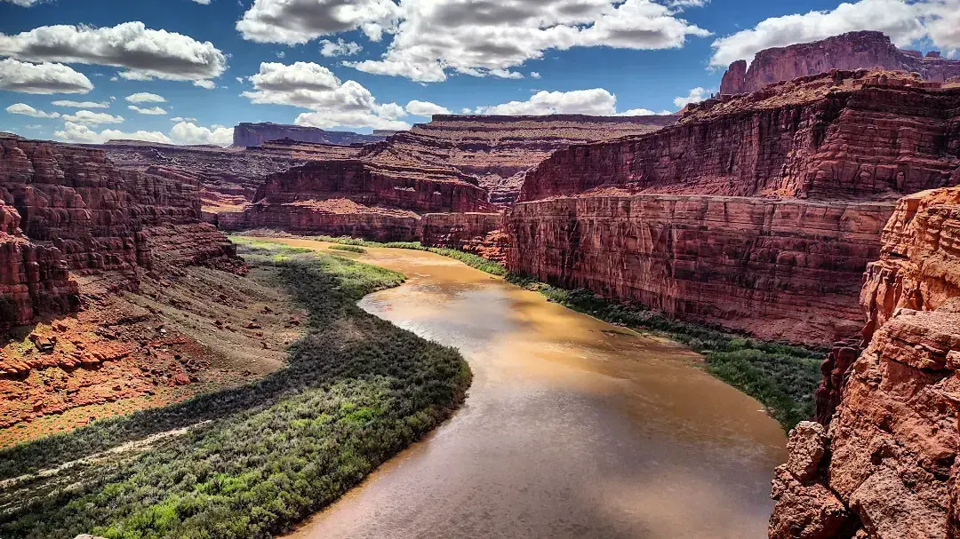
More than just a river, the Colorado is the heart and soul of Moab. Whether you’re on a peaceful float or a thrilling rafting trip, the massive sandstone spires and redrock walls provide an awe-inspiring backdrop for this aquatic playground.
Recreation is central to this stretch of the Colorado River. As the only part of the river reachable by paved highways in Utah, the area around Moab and the Colorado River is one of the most beautiful in the United States.
To experience this unforgettable scenery, we recommend driving the Utah Scenic Byway 128.

Rafting, canoeing, kayaking, paddle boarding, and boating can all be experienced on Moab’s slice of the Colorado River.
Just upriver from the town of Moab, the Fisher Towers stretch of the Colorado River is known as the most popular one-day river trip in Utah. It features a family-friendly combination of calm water and mild to moderate rapids. Then, the waters of Meander Canyon are calm before entering the famous “Cataract Canyon” known as the best whitewater rapids in the lower U.S.
Water Brings Life
The Colorado River and the use of its water has shaped the history of Utah, Colorado, Arizona, California, Nevada, New Mexico, and Wyoming, which depend on it and its tributaries for life-giving water. In these states, the Colorado River supplies water for 40 million people and has transformed desert land into five million acres of irrigated farmland. These seven states, plus Mexico, and 23 Native American tribes share water rights to the river under the Colorado River Pact of 1922.
More water is distributed from the Colorado River’s 250,000-square-mile basin than from any other river basin in the world. Every drop of water in the river is fully allocated.
Controversies over water rights have long raged, giving meaning to the saying: “Whiskey is for drinking and water is for fighting.” The Colorado is easily the most depended on river of the southwestern United States.
By the Numbers
The river’s 1,450-mile journey starts as a trickle of snowmelt high in the Colorado Rocky Mountains, then travels through mountain canyons
and three major deserts.
The river passes through 11 different national monuments and parks including Rocky Mountain National Park (where it begins), Canyonlands National Park, and Grand Canyon National Park.
The average width is 300ft across with an average depth of about 20ft.
Agriculture uses approximately 80% of the water to irrigate 15% of the nation’s farmland, and supplies a majority of carrots, lettuce, and other vegetables in the winter to U.S. consumers.
The water passes through 33 reservoirs, 188 pumping plants, 345 diversion dams, 50 power plants, and 14,590 miles of canals.
The river supports a $26 billion river-recreation industry. The Fisher Towers section of the Colorado is the most popular one-day river trip in Utah. Don’t miss a trip down the river!
Diversion of the River
Not all states have water rights or water usage regulations.
However, water rights, and diverting water for use, began in the late 1800s in Colorado.
What most folks don’t realize is that one of the first major diversions of the Colorado River is the 16-mile-long Grand Ditch, right near the headwaters, in what is now Rocky Mountain National Park.
The Ditch is only one of the ways water from the Colorado River is diverted to the east side of the Continental Divide. Currently, about half the water flowing down the South Platte River (in Denver and flowing to Nebraska) actually comes from the Colorado River. About half of the water supplied to Denver residents comes from the west side of the Continental Divide and the Colorado River.
Water from the Colorado River not only supports thousands of acres of crops in the west, but also on the eastern plains.
Drying Up
The river’s flow has shrunk by about 20% since the 1900s, mostly due to climate change. The largest reservoir in the United States, in terms of water capacity, is now only 34% full.
Lake Powell, the second largest reservoir on the Colorado River, is only 37% full. Lake Powell has a shoreline larger than the entire Pacific coastline from Washington to California.
The water is currently so low that the ferry that crosses the lake on Utah Hwy 276 can’t run. They have no date for when the service will start again.
These are both huge lakes and these low levels affect who will have water use or get electricity from the dams. The low water also changes the recreational use and experience.
Did You Know?
Moab is the largest town in Utah along the banks of the Colorado River. Yet, the Town of Moab does not take one drop of water for domestic use from the Colorado River. How is that true?
The city’s drinking water comes from the Glen Canyon Group aquifer, the thickest aquifer of the Dakota-Glen Canyon aquifer system. An aquifer is when a water-bearing rock readily transmits water to wells and springs. Moab’s water comes from these natural spring-fed water sources.
The water is then gravity-fed into well pump houses that are then transferred to the community. The water is tested regularly and is good to drink.
Aquifers are recharged by rain and snowfall. So when the La Sals have a big snow year, or there is a rainy season, the aquifers fill up.